Exactly one month after the historic wildfire began and forced thousands to flee, residents of the Fort McMurray area are finally set to re-enter the city. Starting June 1st the city’s four-day, five-zone, phased re-entry plan will commence. If that sounds complicated, its because it was. The city’s officials and emergency managers had to mutually agree to move forward with the plan, which was contingent upon five infrastructure and safety criteria being met:
- Wildfire is no longer an imminent threat to the community;
- Critical infrastructure is repaired to provide basic service;
- Essential services, such as fire, EMS, police and health care, are restored to a basic level;
- Hazardous areas are secure;
- Local government is re-established.
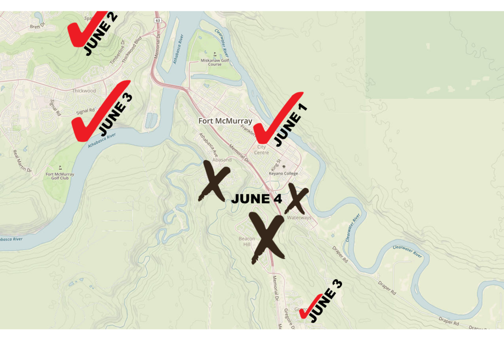
Even though the minimum criteria have been met, the area will be assessed daily. The plan’s phases allow residents of the least-damaged areas to return home first, though not all residents will be allowed to return to the city. The presence of harmful chemicals (including arsenic) in the ash, soil and air may delay residents’ permanent return in the communities of Abasand, Beacon Hill, and Waterways. Officials are understandably cautious for those areas and will base the permanent re-entry in those three neighborhoods (seen as ‘x’ on in Figure 1) on future non-toxic test results. Homeowners will merely be able to visit on June 4th but will need other permanent accommodations for the foreseeable future. “Despite the significant work that has been done, the city today is not the city that residents left behind a month ago. A boil-water advisory remains in effect, some health-care services are not available, and many businesses will not be open,” the Alberta Premier Rachel Notley said.
Re-entry Dates and Communities:
- June 1st: Lower Townsite, Anzac, Fort McMurray 468 First Nation, Gregoire Lake Estates (Zone One)
- June 2nd: Parsons Creek, Stone Creek, Timberlea, Eagle Ridge, Dickinsfield (Zone Two)
- June 3rd: Thickwood, Wood Buffalo (Zone Three) AND Gregoire, Prairie Creek, Saprae Creek Estates (Zone Four A)
- June 4th: Waterways, Abasand, Beacon Hill, Grayling Terrace, Draper (Zone Four B)
Figure 1: Re-entry plans for Fort McMurray. X’s represent non-permanent re-entry.
Fort McMurray Wildfire update
As for the Fort McMurray fire itself, it has been mapped at 1000 km or 580,000+ hectares (1,434,780 acres), and is now 40% contained. The fire officially impacted 567 homes and 12 apartment complexes in Fort McMurray, with 85-90 percent of residences seeing no damage. 2,400 buildings and 665 work camp units have been reported as lost overall. Initial insurance payout estimates are around 9 billion Canadian dollars, making this disaster the most expensive in Canadian History by a hefty margin of 7 billion. Oil sands operations in the area have halted, costing ‘Big Oil’ an estimated 1 billion ca dollars as well.
The fire continues to scorch remote forests of Alberta and even a small portion of Saskatchewan. Extreme burning conditions are still being seen in some areas of the fire. Higher humidities and the potential for rain should aid the fire fight in the near future, but firefighters from seven Canadian provinces and two countries (USA & South Africa) remain assigned to continue the containment battle across Alberta.
Sources: Alberta.ca Wildfire Update, Huffingtonpost Canada, Wikipedia


